
Remote sensing images (obtained through satellites, planes or drones) can be of great interest for the execution of certain agricultural survey studies. where it is interesting to have at its disposal a geolocalized data source, that is reliable and reproducible by the opposing party in order to avoid it being disputed.
Some examples of such applications include irrigation certifications, which demostrate the use of irrigation rigth given a certain data range, farms apprisal, for appraisals or productivity assessments, insurance claims for damages due, for example, weather events, settlement of boundaries or right of way disputes, or any other study that the expert surveyor needs to prove certain use, present or past, that can be analyzed through images adquired by satellites or aerial platforms.
An export report based on remote sensing data can be used in an insurance claim, in an appeal to a public administration or even in court proceedings if necessary.
Irrigation certifications
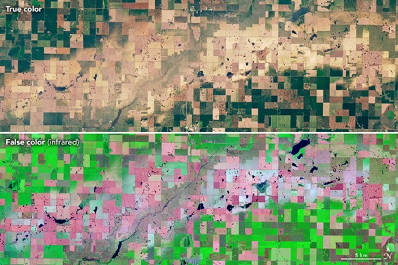
The existence of a satellite image archive, for example the case of Landsat, free and open since the 70s, enables to perform historical studies of the presence of irrigation crops. From these analysis we can, for example, prove that a given farm was irrigating before certain date or date range and therefore holds irrigation rights or can challenge the expiry of a concession.
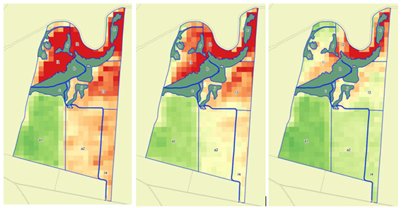
Evolution of the NDVI index between may and june of 1997.
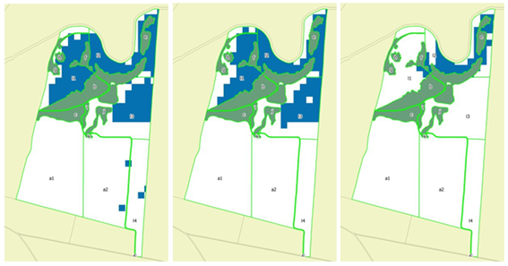
Calculation of irrigated surface per plot between may and june of 1997.
Property valuation
Images obtained through drones or satellites are a very interesting tool to assess the current state of a property, its evolution over time or to evaluate its past behaviour. This information can be used to carry out farms appraisals or to carry out historical productivity studies and include them in the valuation.
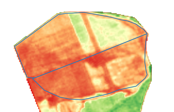
Example of satellite image where management patterns are observed.
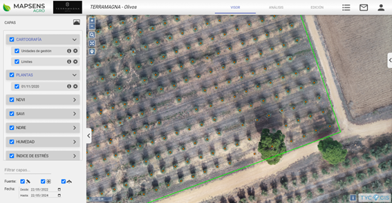
Mapsens Agro App showing an inventory of olive trees generated through drone flight for a farm valuation.
Insurance claims
The fact that satellite images are a truthful and replicable data source, they can be used as a basis for agricultural insurance claims, for example in the case of climate events such as drought, frost, hailstorms, etc. As well as mapping and detecting the affected area, we can classify the surface area depending on the severity of the damages and provide much more detailed and complete information.
Damage on crops caused by hailstorm (Top natular color, bottom infrared false color).
Source: NASA Earth Observatory, Landsat 8, 2018.
Boundary disputes and rigths of way.
Not only satellite images can have expert value, but also aerial photographs taken by different state and regional public entities, such as Instituto Geográfico Nacional (IGN) in Spain or the geographical services of Autonomous Communities or City Councils.
Comparison of official cadastral mapping with current and historical aerial photograph can help analyze or resolve conflict between different landowners over the position of boundaries or right of way to the properties.
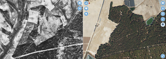
American flight orthophoto (1956, left) and PNOA most current (2022, right).
At TYC GIS we have extensive experience on both the preparation of expert survey informs for agricultural applications and on other fields, such as expert testimony in legal proceedings.
 (2 votos, promedio: 5.00 de 5)
![]() Loading...
Loading...
Leave A Comment