
Some weeks ago, we talked about a project carried out for EULEN of a QGIS plugin for urban inventory management. This time, we have a new project for EULEN. On this ocassion, for the urban inventory management of Avilés.
It may seem that the elements a cityhall needs to inventory are always the same and sometimes very similar, yet they always have some pecularities and specific needs. That’s why having at our disposal an app created ad hoc for our specific case and needs is an advantage over a prefab software that may require us to adapt to it.
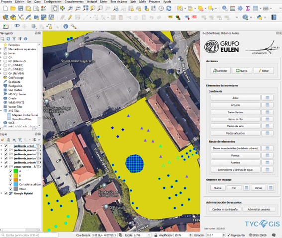
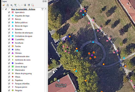
The Avilés plugin consist on 10 layers, 6 of them of lanscaping (tree, bush, green areas, flower massif, hedge massif, bush massif). These layers have their own field and symbology collection, specifically created for the representation needs of the customer data. On the other four layers (Inventoriable assets, Promenades, Fountains and Rolling mills and water sheets), the data base had to be adapted and a new symbology had to be created for the inventoriable assets, given the wide variety of the inventoried elements.
The plugin also has a user administration section that gives control of user administration to the customer. This allows them to create or erase users, as well as assigning and varying their roles. This way, we can vary someones role from a technician with acces to make changes on the elements into an administrator able to creat new users or revoke a workers acces to the data base if he or she leaves the position.
Another challenge in this kind of works is often the massive loading of data that was taken before the creation of the data model, as it does not always the created data model fits the older one or every data taken above adjust o it. Usually, you have to face a series of layers, excel tables or CSV, where the names of the fields change from one data source to other ones, some are incorrect or non-existant, etc. That’s why, during the data migration phase, we generate some data loading python scripts adjusted to the specific needs of the situation. We detect and correct systematic errors with nomenclatures, coding, wrong or missing data.
Once the data uploading is done, the customer inmediately began to inventory using a tablet with windows 10 in the field, which allowed to use QGIS. The performance was good, considering it was not designed to be used on a tablet, and has made it possible to carry out inventory work in the field with our plugin, which has been a great help in facilitating its execution.
Customer:

If you need help with a similar project, please contact us here TYC GIS.
 (2 votos, promedio: 5.00 de 5)
![]() Loading...
Loading...


Leave A Comment